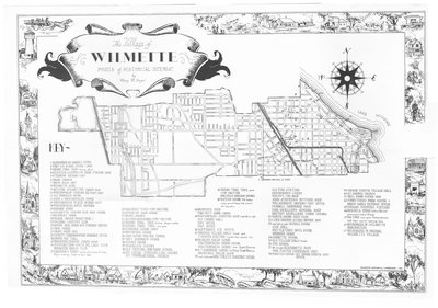
The Village of Wilmette Points of Historical Interest
Description
- Creator
- Mary M. Engel, Artist
- Media Type
- Image
- Text
- Item Type
- Maps
- Description
- Map of Wilmette with numbered dots showing location of historical places in Wilmette. Former and current street names used side-by-side.
- Inscriptions
- 1 Alexander McDaniel's Home, 2 First Log School House 1845, 3 Indian Trail Tree bronze plaque, 4 Hillville or Llewelyn Park station 1845, 5 Stebbins Taven 1837, 6 Bahai Temple, 7 Brick kiln 1857, 8 Wilmette bowl, 9 Antoine Ouilmette's cabin 1826, 10 Westerfield's vinegar factory 1855, 11 Old Franklin house, 12 John G. Westerfield's home, 13 Westerfield's pickle works 1855, 14 Westerfield's apple orchard, 15 Dusham home, 16 Ouilmette Country Club golf course, 17 Michelet home, 18 parade ground World War I, 19 Original country club, 20 Henry Gage home 1876 Tornado Tavern, 21 Gage home, 22 Gage's pier 1876, 23 County Commissioner's drainage ditch, 24 Green Bay Trail, 25 Beaubien-Dennis cabin 1843, 26 Foundations Vista Del Lago Club Breakers Beach Club, 27 Mahoney Farm with names of the survivors of the Lady Elgin sinking listed on barn door, 28 Mahoney pond cow pasture, 29 Augustus Gage home, 30 Drury Homes, 31 Asahel Gage home and cow pasture, 32 Indian Trail tree bronze plaque marker, 33 Indian Trail Tree now gone, 34 Dunshee home 1889, 35 Panushka home, 36 Law house and water tower, 36 Cap't Howard's home, 38 Dingee House, 39 Wheelock Houses, 40 Old Central One-Room School, 41 Joy House Springer-Ling houses, First Congregational Church, 42 Indian Trail Tree now gone and cow pasture, 43 Bockius House- old Indian camp ground- house build around old log cabin, 44 Dahncke's shop and Fred Witt Home and dairy, 45 Westerfield's Surveyer shop-read left to right- Old Library Hall, Post Office, Post Office, 46 Hoffman's Ice Office, 47 ORiginal Village Hall-faced west, C&NWRR station-moved from present site, 48 Dr. Ralph Child's Home-Westerfield's farm house-Westerfield's home-now Scott's Funerals, 49 A.T. Sherman home-1st village trustee meeting-Dahncke's Tailor Shop, 50 read clockwise-Mrs. Curley's Boarding House-Old Fire Station-Henderson's Livery-Wolff's Tin Shop-John Steffen's Butcher Shop-Wm. Kinney's Grocery & Post OFfice-Hubbell Hardware Shop-Max Mueller's General Shop-Baptist Mueller's Three Houses, 51 North Shore Golf Club, 52 Luer Grocery Store before 1890, 53 read left to right-Russell House, I.O.O.F. Hall, Nettleton's Drug Store, Springer Home, 54 Corrette House, 55 Old Village Hall-moved, 56 2nd school, 57, left to right-blacksmith shop, Wm. Foster Cooperage 1839, 58 Nanzig House-1st Grosse Pointe Post Office, 59 Grosse Pointe Village Hall, 60 St. Joseph's Church, 61 Bell Farm House 1956, 62 Corruther's Farm House & barn-Early express office, 63, Indian chipping station, 64 Rengel's farm-Indian mound-permanent Indian Village, 65 Big Tree-now gone-Pottawatamies held council meetings here, 66 Boundaries of Ouilmette reservation, 67 Boundaries of original Wilmette Village
- Place of Publication
- Wilmette, Illinois, USA
- Date of Publication
- 1953
- Dimensions
-
Width: 23 in
Height: 18 in
- Corporate Name(s)
- Wilmette Historical Commission
- Local identifier
- Map 9
- Language of Item
- English
- Geographic Coverage
-
-
Illinois, United States
Latitude: 42.07225 Longitude: -87.72284
-
- Copyright Statement
- Protected by copyright: Uses other than research or private study require the permission of the rightsholder(s). Responsibility for obtaining permissions and for any use rests exclusively with the user.
- Copyright Holder
- Wilmette Public Library
- Terms of Use
- Image may be used with credit to Wilmette Public Library
- Contact
- Wilmette Public LibraryEmail:refdesk@wilmettelibrary.info
Website:
Agency street/mail address:1242 Wilmette Avenue
Wilmette, IL
60091-2558
U.S.A. Phone: 847-256-6930


