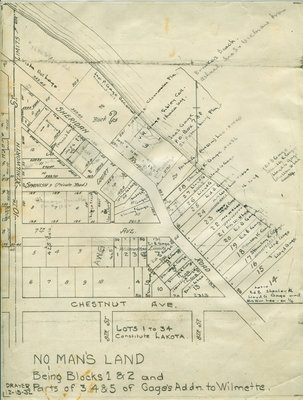
Hand drawn map No Man’s Land
Description
- Media Type
- Image
- Text
- Item Type
- Maps
- Description
- No Man's Land Residents’ names written in ink.
- Notes
- No Man's Land annexed to Wilmette, Illinois, in 1942.
- Inscriptions
- On reverse in pencil: H.S. Marshall, 231 So. LaSalle
[Annotations] [Lakefront property owners] Vista del Lago; Jno. P. Gage deceased; Breakers Beach; Ashael, Jno. S. and Victor are bros.; Gage, Clearwater, Fla.; V. R. Gage, Sibley Coll, Ithaca, NY; Jnos. Gage, P.O. Box 738, St. Petersburg, Fla.; Portia G. Lee (Mrs. William H. Lee); Stanley K. Gage; Lloyd G. Gage; Ed. B. Gage; Mrs. Wm. Lee; Lloyd Gage; Mrs. W. H. Lee; Stanley K. Gage; [Lots west of Sheridan Road] Miralago; Porcius Gage; Spanish Court (private road); Portia G. Lee; Stanley Gage; 7th Ave.; Ed. B. Gage; Stanley K. Gage; Portia G. Lee; Lloyd Gage; Chestnut Ave.; Lots 1 to 34 constitute Lakota; 9th St.; 8th St.; 10th St.; Kenilworth; No Man's Land being Blocks 1 & 2 and Parts of 3, 4& 5 of Gage's Addn. to Wilmette; Drayer; 12-15-32 - Date of Publication
- 15 Dec 1932
- Dimensions
-
Width: 8.5 in
Height: 11 in
- Subject(s)
- Local identifier
- Map 7
- Language of Item
- English
- Geographic Coverage
-
-
Illinois, United States
Latitude: 42.0876664699221 Longitude: -87.7027556188965
-
- Copyright Statement
- Public domain: Copyright has expired according to United States law. No restrictions on use.
- Terms of Use
- Image may be used with credit to Wilmette Public Library
- Contact
- Wilmette Public LibraryEmail:refdesk@wilmettelibrary.info
Website:
Agency street/mail address:1242 Wilmette Avenue
Wilmette, IL
60091-2558
U.S.A. Phone: 847-256-6930


