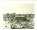
Aerial view downtown Wilmette, 1924 looking east. The X streets are the intersection of Central and Wilmette Aves.
Description
- Media Type
- Image
- Item Type
- Photographs
- Notes
- Aerial photograph of Wilmette, Illinois, village center taken November 21, 1924.
- Inscriptions
- [annotation on back of the photograph] Note 11 car steam train with open vestibules pulling into station. You can see the difference in color in the Village Hall between the first and second floors. The addition or second floor was added in 1920-21. You can see the old Carnegie Library at Park and Wilmette Ave. Note the four homes to the east of the library. Note the old St. John's Lutheran Church at Park and Wilmette and the Methodist Church at Lake and Wilmette Avenues. On Central Ave., west of Green Bay, note the house where the Post Office is and also no "Pioneer Press" building. You can see Stolp, Central, and 10th Street school buildings at Central and 10th street. Note the house standing where Smithfield Foods was located. Also the house where the National Food Store is now located.
- Date of Publication
- 21 Nov 1924
- Subject(s)
- Corporate Name(s)
- Central Elementary School ; National Food Store ; Smithfield Foods ; Stolp School ; St. John's Evangelical Lutheran Church ; Trinity United Methodist Church ; Wilmette Village Hall
- Local identifier
- Aerial Views No. 1
- Language of Item
- English
- Geographic Coverage
-
-
Illinois, United States
Latitude: 42.0762796661712 Longitude: -87.7078491338158
-
- Copyright Statement
- Copyright status unknown. Responsibility for determining the copyright status and any use rests exclusively with the user.
- Contact
- Wilmette Public LibraryEmail:refdesk@wilmettelibrary.info
Website:
Agency street/mail address:1242 Wilmette Avenue
Wilmette, IL
60091-2558
U.S.A. Phone: 847-256-6930


