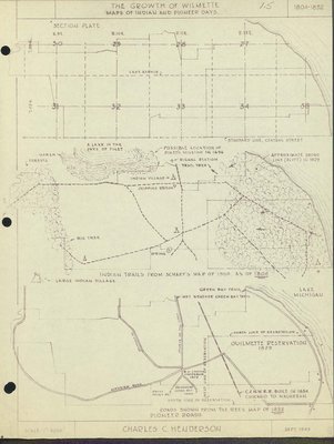
Maps show marsh, forests, a lake in the days of Pinet, possible location of Pinet's Mission in 1696, signal station, Indian village, chipping station, trail tree, approximate shore line (bluff) in 1828, a spring, Indian trails from Scharf's Map of 1900 as of 1804, Green Bay Trail, Lake Michigan, wet weather Green bay Trail, Ouilmette Reservation 1829, C.N.W. R.R. built in 1854 Chicago to Waukegan, South line of hte reservation, W. J. Fostero Cooperate 1838, Glenview Road, Gross Point Road, Roads Shown from the Rees Map of 1852
The Growth of Wilmette: Maps of Indian and Pioneer Days
Description
- Creator
- Henderson, Charles Clinton, Cartographer
- Media Type
- Text
- Image
- Item Type
- Maps
- Notes
- Three small maps showing changes in Wilmette from 1804-1852.
- Place of Publication
- Wilmette, Illinois
- Date of Publication
- Sep 1949
- Date Of Event
- 1804-1852
- Subject(s)
- Local identifier
- Maps 1.5
- Language of Item
- English
- Geographic Coverage
-
-
Illinois, United States
Latitude: 42.07225 Longitude: -87.72284
-
- Copyright Statement
- Copyright status unknown. Responsibility for determining the copyright status and any use rests exclusively with the user.
- Contact
- Wilmette Public LibraryEmail:refdesk@wilmettelibrary.info
Website:
Agency street/mail address:1242 Wilmette Avenue
Wilmette, IL
60091-2558
U.S.A. Phone: 847-256-6930 - Full Text


