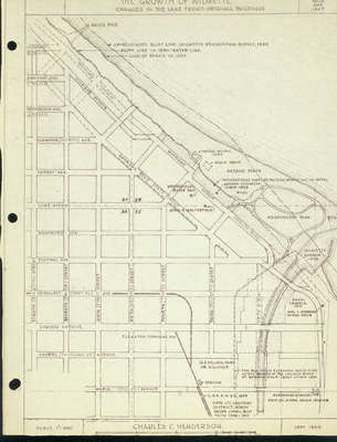
Gage's Pier,
Chestnut
6th Sixth Ave.
Ashland Ave.
5th Fifth Ave.
Greenwood Ave.
4th Fourth Ave.
Elmwood Ave.
North Ave.
Forest Ave.
Lake Avenue
Washington Ave.
Central Ave.
Greenleaf Ave.
Depot Pl., Place
Linden Avenue
Laurel Avenue
Michigan St.
Maple Ave.
Hill St.
Eighth Street
8th Street
Division St.
Seventh St.
7th St.
Grove St.
Sixth Street
6th St.
First Street
1st St.
Fifth Street
5th St.
Second Street
2nd St.
Fourth Street
4th St.
Third Street
3rd St.
Michigan Avenue
Sheridan Road
State Street
Baha'i Temple 1921
Joel C. Stebbins Tavern 1837-8
Wilmette Harbor 1908
Washington Park
Pier
Bowl
Antoine Ouilmette Cabin 1829
Westerfield's pickle factory,
Westerfield's vinegar factory washed out by waves
bathing beach
beach house
water works 1934
Approximate bluff line, Ouilmette reservation survey 1829
Bluff line in 1890= water line
Line of beach in 1947
Gage's Pier
The Big Ditch extended south to the North Branch of the Chicago
River at Bowmanville, built approximately 1880
Alexander McDaniel
First log school house 1845
Cook Cty. County Sanitary District North Shore Canal built from
1906 to 1910
C.H.S. & M.R.R. 1899
Llewellyn Park or Hillville
station
Elevated terminal 1912


