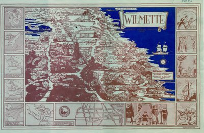
Pictorial map of Wilmette
Description
- Creators
- Edward Perkins, Cartographer
- Alex Rindskopf, Artist
- Riehard Rindskopf, Artist
- Media Type
- Image
- Text
- Item Type
- Maps
- Description
- Pictorial map of Wilmette, Illinois, historical sites in blue and shades of rose.
- Date of Publication
- 1950
- Dimensions
-
Width: 11 in
Height: 17 in
- Subject(s)
- Corporate Name(s)
- Wilmette Historical Commission
- Local identifier
- Map 10
- Language of Item
- English
- Geographic Coverage
-
-
Illinois, United States
Latitude: 42.07225 Longitude: -87.72284
-
- Copyright Statement
- Protected by copyright: Uses other than research or private study require the permission of the rightsholder(s). Responsibility for obtaining permissions and for any use rests exclusively with the user.
- Copyright Date
- 1950
- Contact
- Wilmette Public LibraryEmail:refdesk@wilmettelibrary.info
Website:
Agency street/mail address:1242 Wilmette Avenue
Wilmette, IL
60091-2558
U.S.A. Phone: 847-256-6930