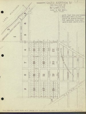
Gage's Addition to the Village of Wilmette used in the 1870s
Description
- Creator
- Henderson, Charles Clinton, Cartographer
- Media Type
- Image
- Text
- Item Type
- Maps
- Notes
- Map of Wilmette in the 1870s. The map shows east and west alleys south of North Avenue. The original plan had north and south alleys.
- Inscriptions
- Wilmette Village; Gage's Addition to the Village of WIlmette used in the 1870's scale 1" = 500'; Nothe that this map shows East and West Alleys south of North Avenue. The original plan had north and south alleys.; This partial copy does not show lot dimensions nor residences as on the original; Lake Michigan; Michigan Ave. south; Seventh (7th) Ave.; Sixth Ave.; Fifth Ave.; Fourth Ave.; North Ave.; Forest Ave.; Lake Ave.; L. L. Greenleaf's Resubdivision; North line of Ouilmette reservation; Wilmette Ave.; William St.; Park St.; Gage St.; C&M-R-R; Lake Michigan
- Date of Publication
- 26 Nov 1947
- Date Of Event
- 1870
- Subject(s)
- Local identifier
- Maps 1.9
- Language of Item
- English
- Geographic Coverage
-
-
Illinois, United States
Latitude: 42.07225 Longitude: -87.72284
-
- Copyright Statement
- Copyright status unknown. Responsibility for determining the copyright status and any use rests exclusively with the user.
- Contact
- Wilmette Public LibraryEmail:refdesk@wilmettelibrary.info
Website:
Agency street/mail address:1242 Wilmette Avenue
Wilmette, IL
60091-2558
U.S.A. Phone: 847-256-6930