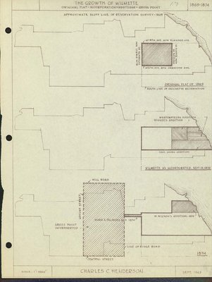
The Growth of Wilmette: original plat incorporation-additions--Gross Point, 1869-1874
Description
- Creator
- Henderson, Charles Clinton, Cartographer
- Media Type
- Image
- Text
- Item Type
- Maps
- Notes
- Map covers development from 1869-1874. Shows original plat of survey 1869; Wilmette as incorporated, Sept. 19, 1872; and Wilson's addition and Gross Point 1874.
- Inscriptions
- Approximate Bluff line of reservation survey, 1829; North Ave. now Emwood Ave.; Elm St. now Fifteenth St.; Division St. now eighth St.; South Ave., now Oakwood Ave.; Original plat of 1869; south line of Ouilmette Reservation; Westerfield's addition; Dingee's addition; Lake Shore Addition; Wilmette as incorporated, Sept. 19, 1872; Hill Road; Locust Sttreet; Gross Point Incorporated; Munn & Palmer's Addition 1874; M. Wilson's Addition 1874; Line of Ridge Road; Central Street. Scale 1"=3200'
- Date of Publication
- Sep 1947
- Date Of Event
- 1869
- Subject(s)
- Corporate Name(s)
- Gross Point (Ill.)
- Local identifier
- Maps 1.7
- Language of Item
- English
- Geographic Coverage
-
-
Illinois, United States
Latitude: 42.07225 Longitude: -87.72284
-
- Copyright Statement
- Copyright status unknown. Responsibility for determining the copyright status and any use rests exclusively with the user.
- Contact
- Wilmette Public LibraryEmail:refdesk@wilmettelibrary.info
Website:
Agency street/mail address:1242 Wilmette Avenue
Wilmette, IL
60091-2558
U.S.A. Phone: 847-256-6930


