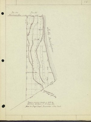
The Growth of Wilmette: Map from a survey made in 1840
Description
- Creator
- Henderson, Charles Clinton, Cartographer
- Media Type
- Text
- Image
- Item Type
- Maps
- Notes
- Map derived from a survey made in 1840 by William Milburn of St. Louis, Mo. Map is in the Engineering Dept. Evanston City Hall.
- Place of Publication
- Wilmette, Illinois
- Date of Publication
- 1949
- Date Of Event
- 1840
- Subject(s)
- Local identifier
- Maps 1.4
- Language of Item
- English
- Geographic Coverage
-
-
Illinois, United States
Latitude: 42.07225 Longitude: -87.72284
-
- Copyright Statement
- Copyright status unknown. Responsibility for determining the copyright status and any use rests exclusively with the user.
- Contact
- Wilmette Public LibraryEmail:refdesk@wilmettelibrary.info
Website:
Agency street/mail address:1242 Wilmette Avenue
Wilmette, IL
60091-2558
U.S.A. Phone: 847-256-6930